The Lauren, A Condominium
Emergency Tips 
Courtesy of the District of Columbia Department of Transportation
(Updated 10/25/2005)


General Tips

During an incident, stay where you are unless directed by authorities to evacuate. Staying in your location is usually the most prudent course of action unless you are in immediate danger. Do not assume that you should evacuate. 

If evacuation is appropriate, listen for the message indicating direction to proceed and signs to follow. Information will be provided to the public through the media. Your best initial action is to “shelter in place” and stay attentive to media broadcasts.

Plan to walk or use transit. Metrobus and Metrorail will be operated to maximize evacuation.

If you leave your vehicle, make sure it is secure and not parked on an Emergency Evacuation Route.

If you have a car, it is best to try to keep at least 1/2 tank of gas in it at all times.

Evacuation Route Information

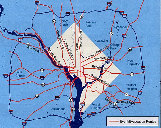
Twenty-Five (25) streets radiating from downtown Washington, DC are identified as emergency event/evacuation routes. The routes extend to the Capital Beltway (1-495) and beyond.

Outbound signs direct motorists to 1-495 in Maryland and Virginia. Inbound signs show images of monuments (see below). Evacuation routes are also identified by street name signs, which include the red and white District flag. (3 red stars located above 2 red bars)

Pennsylvania Avenue, NW, between Rock Creek Park and the US Capitol is the dividing line for egress routes if directions are given to evacuate the DC Central Business District.

None of the evacuation routes cross and no vehicles will be permitted to cross the Pennsylvania Avenue dividing line during an emergency evacuation.

Traffic signals (lights) will be timed to move traffic away from the event/incident area across jurisdictions.

Critical intersections on the emergency evacuation routes within Washington, DC will be staffed by uniformed law enforcement officers to expedite vehicle and pedestrian traffic.

All of the evacuation routes radiate out of the city and feed into the beltway (1-495 loop), allowing motorists to access all points north, south, east and west.

Evacuation routes may be used as ingress routes to bring people into DC should the evacuation of a jurisdiction in the Washington Metropolitan Region become necessary. Event conditions in an evacuation may also require identified evacuation routes to become dedicated ingress routes.


Create an Emergency Plan

Discuss with your family how you will respond to an emergency. 

Pick a friend or relative that all family members can call if separat ed (consider an out-of-state point of contact as it may be easier to call out of state during an emergency than in the local area).

Prepare an emergency Go Kit (the kit should have a 3-day supply of fooa water, medical items, first aid supplies, a flashlight, radio batteries, etc.)

Become familiar with the District’s Family Preparedness Guide which is available through the Emergency Management Agency, and online at http://dcema.dc.gov

Emergency Information

HIGHWAY ADVISORY RADIO

The District of Columbia has a Highway Advisory Radio (HAR) station (1650 AM) to provide motorists with information regarding incidents and or emergencies in the DC area.

EMERGENCY ALERT SYSTEM

In the event of a serious emergency, the District of Columbia may activate the Emergency Alert System (EAS). 

The EAS permits local government offi cials to broadcast timely information and instructions in case of possible or actual local emergencies. The primary radio stations (FM/AM) to listen to in the District include the following:

WTOP 1500 AM, 820 AM. 1 07. FM 
WMAL 630 AM
WGMS 103.5 FM 
WJZW 105.9 FM 
WK YS 93.9 FM 
WHFS 99.1 FM 
WPGC 95.5 FM

BIKE TRAILS

In the event of an evacuation, the following hike trails can he used by cyclists and or pedestrians.
  1. Rock creek Park Trail
  2. C&O Canal Tow Path Trail
  3. Capital Crescent Trail
  4. Suitland Parkway Frail
  5. Custis Trail (1—66) 
  6. Mt. Vernon Trail (via 14th Street Bridge)

Information on bicycle commuting and trails

www.waba.org and www.hikewashington.org and www.commuterconnections.org

Key Telephone Numbers

Police. Fire or Medical Emergencies 911
D.C. Emergency Management Agency (24 hour)  202 727-6161
Police Non-Emergencies 311
MPD Command Center (24/7 line for reporting suspicious activities) 202 727-9099
Joint Terrorism Task Force 
(24/hr line for reporting suspicious activity)
202 727-2000
WASA - (Water and Sewer Authority Emergency Number) 202 612-3400
Washington Gas (Natural Gas Emergency Number) 703 750-1400
PEPCO - (Life-threatening emergencies) 202 872-3432
Department of Homeland Security 800 237-8322